Wednesday 21 March 2012

yet another academic publishing blog

I have seen a variety of other blogs discussing the problems in the academic publishing system, with many discussions as to *why* the system is continuing to thrive, depsite the presence of the internet having rendered most of the services provided by publishers obslete. However, none of the discussions which have crossed my path address what, to me, is likely the biggest reason. As scientists our publication records matter—if we don’t have “enough” first-author papers published we don’t land jobs in acaidmeia, and we don’t get grants if we have jobs. The universities for which we work are ranked, in part, by the number of publications we produce, and the quality of the journals in which we publish. The more “A” ranked journal articles produced by a given university, the better it is considered to be, and the easier time it has of getting funding. So long as funding decisions are based, in part, on our list of publications, and so long as the prestiege of the journals in which we are publishing matters, the system will continue to thrive, despite so many of us being unhappy with it. Is there hope of this changing? Perhaps, if enough people want it to change.

Tuesday 20 March 2012

Geology field trip at Arlanda airport


The next time you have too many hours to wait for your next flight at Stockholm-Arlanda airport why not step outside and have a short geology field trip?

I had a long layover on my way to France, and it was much too nice of a spring day to spend the wait inside. The first thing I noticed when I stepped outside is that spring in southern Sweden is much further along than it is in the north. At home the snow was still fully covering the ground, though starting to get soft and melty. Down here there is no snow left at all, though the flattened, yellow state of the grass attests to the fact that there was snow on the ground fairly recently.ere is

I set out from Terminal 5, following the bike/walking path to the
left from the building (note: use the exit on the lower floor; the sidewalk on the upper level dead-ends at the top of the driving ramp to the loading zone). I found the first outcrop straight away: a tall chain-link fence protects unwary travelers from falling over the edge of a small, man-made cliff.


Not being able to resist the allure of a fresh rock surface, I promptly left the trail to investigate. The cliff is actually a channel cut into the rock which ends at a large garage-door.


The rock here is fine grained, dark, and contains small veins, some of which cross-cut one another. The weathered surface shows a bit of foliation to the rock.


The astute observer might notice that along the fence edge there is a bunch of rubble fill which is made up of a coarser grained white rock with elongate black grains showing a foliation.


However, the wait for my flight was quite a long one, and I still wanted to stretch my legs, so I decided to continue my exploration. I continued following the path, turning left at the Statoil station and continuing along the path towards the forest in the distance.

After a short walk I came to a body of water which had an earth-bridge crossing it, leading towards a small hill with rocks exposed at its peak.


What geologist could resist? Closer investigation revealed the source of that white and black rock that is being used as fill everywhere between here and the terminal.


There are plenty of fresh surfaces to admire, sparkling in the sunlight on the side that has served as a quarry.


There are also plenty of examples of how the rock looks 'in place' on the other side of the hill.


It took me only 35 minutes to walk from my gate to the quarry outcrop, and I recommend the adventure to other travellers with time to spare who would rather enjoy fresh air and investigate the local geology than explore the over-priced airport shops.

And to show how far apart the two outcrops are: The view back to terminal from the further outcrop:

And how close the nearer outcrop is to the same control tower:


Thursday 8 March 2012

WoGE # 334


I have been seeing various posts from the Where on GoogleEarth game wandering hither and yon over the geoblogosphere for years now, but never really felt like I had time to play. I did once open GoogleEarth and spend something like 1 minute looking around before deciding that my time that day would be better spent actually doing the tasks for which I had turned on the computer in the first place. Yesterday, however, I decided that it was time to actually give it a go, so when I saw Zane’s post announcing #333 and noted that no one had yet posted an answer (though Florian at EffJot had indicated that he was only waiting for hi

s Sc

hott rule time period to elapse before he posted his answer), I downloaded GoogleEarth (no, I hadn’t gotten to that yet—I only got this computer in November, and hadn’t yet needed it—for quick looking GoogleMaps is adequate).

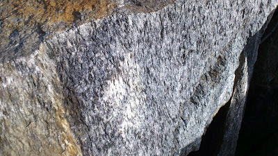
Now, I was lucky with this one—coast lines narrow the search quite a bit, and the style of agriculture and architecture looked sort of English to me, which meant I could focus my search on Britain and places colonized by them. Even so it took a while to find the location, at the mouth of the Wairoa River in New Zealand (North Island). Once I found it I refreshed the page and saw that there were no new comments, so I started a comment of my own,
describing the location and geology. Now, since I am not a sediment person this means that I also spent a couple of minutes consulting with google to find a paper on the geology of the area, so that I would have something to say on the topic.

Once I was done I hit the button to post the comment, only to discover that Florian’s answer had appeared nine minutes before mine. It was a fun game, but I lost, fair and square, and I was quite delighted to have been able to find the location on my first try of playing. However, Florian, being a generous soul argued that given the closeness of the timing of the posts the win (and obligation to host the next one) should go to me. Astute readers will
note that since he had been waiting to post until his time limit was up it wasn’t, truly, that close—he knew the answer before I started looking. Be that as it may, after a bit of discussion he and Zane both agreed that I should take the next go at hosting.

Therefore, without further ado, I introduce you all to Where on GoogleEarth #
334:


I am looking forward to hearing what you can tell me of the geology in this area—from the little I read before selecting this spot you should be able to share some interesting tidbits. Since I directly benefited from the Schott Rule it seems fair to not invoke it this time, so, come on you multi-winners, show us how it is done!

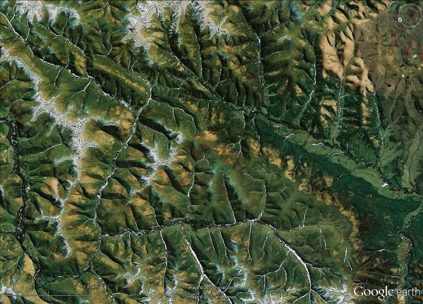
The scale bar, which I drew onto the above image myself, is roughly 5 km long; I didn't know how to get a scale bar to appear automatically in GoogleEarth. Fortunately, it turns out that there are instructions available for these things. Pity I didn't think to look for them before posting this morning. Oh well, this is why it is possible to edit posts.


However, when I made the above image, by using the handy "snip tool" on my computer and saving to jpg, adding a scale bar in a drawing program, and re-saving, the result turned out not to be clickable to make a larger image. Thanks to the below comment, I now know that one can save right from GoogleEarth (see, I told you I wasn't very experienced with the program, it didn't even occur to me to try). The new, improved image is below. Hopefully this time it is possible to zoom in enough to see details.


Nope, not yet. Perhaps I am doing something wrong in blogger when I upload them? At least it has the scale bar, which is 7.01 km long, since I couldn't get enough accuracy with the mouse on the slide bar to get it to stop at 7.00 km. Thanks to the kind help of Florian (see comments) there is now a full size version available over here.

Tuesday 6 March 2012

writing grant proposals gives the writer more benefits than just the potential money they represent

My focus the past few weeks has been preparing a grant proposal. This is my first attempt at a major, multi-page, grant proposal. I have done minor proposals in the past—the field work for my master’s project was funded with a small GSA grant, and I have obtained a fair few travel grants over the years. Indeed, before submitting this proposal I was in the happy place of being able to truthfully state that I have received 100% of the grants for which I have applied. Needless to say, in addition to wanting this proposal to be successful because of what it would mean to my ability to do science (many of the steps in the process are expensive), that past success rate means that I am even more keen to have this application succeed, since it would be lovely to keep the 100% successful rate for a bit longer.

What have I learned about the grant-writing process? Well, for starters it is very good that I did the initial submission of the application a full week before the deadline, even though I knew that I did not yet have all of the information from my boss that I needed. Why? Because I had forgotten, until I saw that section of the webpage, that a grant application, like job applications, require letters of reference. By doing the submission of the first draft of the paper a week early it gave me the opportunity to remember that important detail, and to contact my referees to ask if they would be able to write a letter before the deadline. How would I have looked if I had had to write to them with only a few hours to spare before the deadline? (Note: the letters of reference have the same deadline as the application itself. If they don’t get it in by then their words will not be heard by the review committee. However, the web page is kind enough to email us applicants when our letters of reference are uploaded into the system, so that we know that they are done and don’t need to worry about that part.)

What else have I learned? There are three sections to the application packet. The first is where you describe the planned project: why it is scientifically interesting and why humanity will benefit from the project. The second is where you describe the scientist(s) who will do the research (that would be me, in this case) and explain why my background makes me the perfect person to do this particular research, and the third describes the institution at which the research will be conducted and why it is the perfect place to undertake such a project. Not surprisingly, I found the first two sections easier to write than the third, since I am so new to this institution. Fortunately, my boss was able to provide me with much helpful information to make the third section come together as it should.

I think that the thing which most helped me with this grant application process is all of the many job applications for academic positions I have done over the years since my PhD first started to draw to a close. The two processes are very similar. However, all in all, I think I have a preference for writing grant applications to job applications—there isn’t quite as much riding on it. If I don’t get this grant I still have a job, I still continue to eat and have a roof over my head. In this particular case I even still get to do the research I speak of in the proposal, since this grant is aimed at researchers who already have an employment contract and a project in progress, but wish additional fund so as to improve the list of what they can accomplish in the process. This level of security permits me to be happy about what I have accomplished over the last few weeks of working on the application—I now have an even better understanding of what my research will entail and how and when I will accomplish various tasks. Even if for some reason my grant is unsuccessful I still gain immense benefit from the process of writing up that work plan and the abstract saying what I will be doing. Besides, you never know—mine might be one of the applications chosen for funding. If I didn’t ask they wouldn’t be able to tell me ‘yes”.

Thursday 1 March 2012

not late at all, measuring with a geologic time scale


As the rest of the geoblog sphere is busy offering up their entries to this month's Accretionary Wedge, I am finally able to offer my entry for last month's call.

Why a month behind? Because the call went out while I was in Scotland, and the counter top, ok, floor, I wanted to photograph was in Sweden. So I had to wait till I got home, and then I had to wait another couple of weeks before I found time to head to the city center to get the photos, and then I had to wait till I had time to actually upload them. However, I think you will agree that this particular building stone was worth the wait.

This is the floor at my eye doctor's office, and what a lovely floor it is. Look at the garnets! Look at the banding! I would love to know the location of the quarry that produced this rock.