I have been seeing various posts from the Where on GoogleEarth game wandering hither and yon over the geoblogosphere for years now, but never really felt like I had time to play. I did once open GoogleEarth and spend something like 1 minute looking around before deciding that my time that day would be better spent actually doing the tasks for which I had turned on the computer in the first place. Yesterday, however, I decided that it was time to actually give it a go, so when I saw Zane’s post announcing #333 and noted that no one had yet posted an answer (though Florian at EffJot had indicated that he was only waiting for hi
s Sc
hott rule time period to elapse before he posted his answer), I downloaded GoogleEarth (no, I hadn’t gotten to that yet—I only got this computer in November, and hadn’t yet needed it—for quick looking GoogleMaps is adequate).
Now, I was lucky with this one—coast lines narrow the search quite a bit, and the style of agriculture and architecture looked sort of English to me, which meant I could focus my search on Britain and places colonized by them. Even so it took a while to find the location, at the mouth of the Wairoa River in New Zealand (North Island). Once I found it I refreshed the page and saw that there were no new comments, so I started a comment of my own,
describing the location and geology. Now, since I am not a sediment person this means that I also spent a couple of minutes consulting with google to find a paper on the geology of the area, so that I would have something to say on the topic.
Once I was done I hit the button to post the comment, only to discover that Florian’s answer had appeared nine minutes before mine. It was a fun game, but I lost, fair and square, and I was quite delighted to have been able to find the location on my first try of playing. However, Florian, being a generous soul argued that given the closeness of the timing of the posts the win (and obligation to host the next one) should go to me. Astute readers will
note that since he had been waiting to post until his time limit was up it wasn’t, truly, that close—he knew the answer before I started looking. Be that as it may, after a bit of discussion he and Zane both agreed that I should take the next go at hosting.
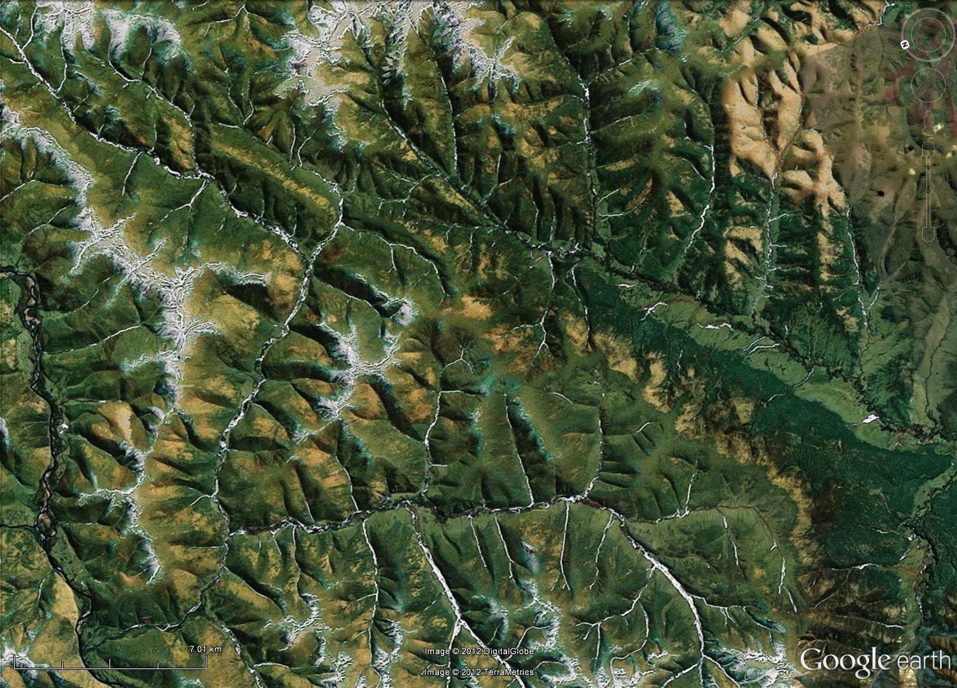
Therefore, without further ado, I introduce you all to Where on GoogleEarth #
334:

I am looking forward to hearing what you can tell me of the geology in this area—from the little I read before selecting this spot you should be able to share some interesting tidbits. Since I directly benefited from the Schott Rule it seems fair to not invoke it this time, so, come on you multi-winners, show us how it is done!
The scale bar, which I drew onto the above image myself, is roughly 5 km long; I didn't know how to get a scale bar to appear automatically in GoogleEarth. Fortunately, it turns out that there are instructions available for these things. Pity I didn't think to look for them before posting this morning. Oh well, this is why it is possible to edit posts.
However, when I made the above image, by using the handy "snip tool" on my computer and saving to jpg, adding a scale bar in a drawing program, and re-saving, the result turned out not to be clickable to make a larger image. Thanks to the below comment, I now know that one can save right from GoogleEarth (see, I told you I wasn't very experienced with the program, it didn't even occur to me to try). The new, improved image is below. Hopefully this time it is possible to zoom in enough to see details.

Nope, not yet. Perhaps I am doing something wrong in blogger when I upload them? At least it has the scale bar, which is 7.01 km long, since I couldn't get enough accuracy with the mouse on the slide bar to get it to stop at 7.00 km. Thanks to the kind help of Florian (see comments) there is now a full size version available over here.


11 comments:
I do have a litte "WogePostingGuide" at : http://woge-felix.blogspot.com/p/how-to.html
I think your picture is not large enough in order to be expandable. If you save your picture as I describe, your picture should be large enough.
I suspect that the issue may be blogger, since I tried saving it the way you suggested, and the result still wont expand when one clicks it, at least not on my screen. But thanks for the link--it didn't occur to me to look for instructions, or that one might save the image in the program itself. I suppose that is what happens when one plays with a new toy too early in the morning...
Additional suggestions to fix the photo issues will be appreciated.
Using Wordpress myself, I don't know how to fix the image size problem in Blogger.
However, if everything else fails, you could send me the full-size image, I would store it on my site and you could put a link to it in your post.
And when will blogger.com finally fix its OpenID issues?
ok, I will try to remember to send you the file in the morning when I head back to the office, since I don't have the file on this computer. What are "OpenID issues?"
The full-size image is available on http://www.effjot.net/img/WoGE334.jpg
OpenID issues: Blogger and Blogspot, i.e. Google, continuously mess up the possiblity to post comments using OpenID (you'll get stuck in an infinite Captcha loop), forcing you to use a Google account or Name&URL. There's nothing you can do about it; Google just doesn't care.
Terrific, now I forgot to post a real, clickable link:
WoGE 334 full-size
64.452071°, -145.348689°
Shaw Creek fault in the Yukon-Tanana Upland is a major left-lateral, strike-slip fault.
The Yukon-Tanana Upland is within the Yukon-Tanana terrane (YTT) which consists predominantly of a mid-Paleozoic volcanic-plutonic (arc?) assemblage built on continental crust. The YTT had experienced strong deformation and metamorphism by Late Triassic time.
By mid-Cretaceous the metamorphic complex and Late Triassic clastic rocks derived from it were imbricated with middle and upper Paleozoic ophiolitic sheets.
The YTT differs markedly from adjacent parts of the North American continental margin in both its depositional and tectonic histories. The composition and tectonic history of the YTT is comparable to that of the Kootenay and Barkerville terranes of southern and central British Columbia from which the YTT may have been displaced. Bounding the YTT on the southwest and northeast are the dextral-slip Denali and Tintina faults. The displacements at these faults are around 450km. The North East trending ShawCreek fault of our picture is perpendicular to these faults.
http://www.eos.ubc.ca/~nchriste/PDF/101-1992%20Beaudoin%20et%20al%20JGR.pdf
LifeLongScholar: did I find what you were looking for? We need your confirmation in order to publish the next Woge.
Felix: LifeLongScholar is on the road and having troubles posting to her blog, but she asked me to congratulate you and let you know that you had successfully identified WoGE #334 and that WoGE #335 is all yours.
Thank you guys! That's a marvelous way of communication :-) . Ron it looks like you are the little wizzard wispering news behind the trees. :-D Anyway, I'm looking forward to your next Woge win.
WoGE335 is ready for hunting.
Post a Comment