Showing posts with label field trips. Show all posts

Friday, 24 September 2010

Deformation in the Desert field trip 2007

Today I read a post by Anne over at Highly Allochthonous on some major flooding she witnessed on her trip to Alice Springs in 2000. This reminded me of my one trip to Alice Springs (it wasn’t flooding when I was there). Since my trip pre-dates my starting this blog, I thought I’d share with you the write-up I did for friends and family.

The below was written on 14 July 2007.

I just returned from the "Deformation in the Desert" Conference, held in Alice Springs, Northern Territory, Australia, sponsored by the Geological Society of Australia Specialist Group in Tectonics and Structural Geology.

The highlight of the conference was the five-day pre-conference field trip (photos below) which looked at the Palaeozoic tectonothermal evolution of the Irindina Province of the eastern Arunta Region. The trip started out in Alice Springs, headed south through the Heavitree Quartzite Gap (the ridge is a wall just south of town, the rocks steeply dipping, with a couple of gaps where the "rivers" cut through--though how you can call a waterless stream course a river, I don't know). From there we took the sealed (read: "paved" if you happen to speak American) road east and thence north into the Strangways and Hearts Range metamorphic complex. As soon as we turned north we were on dirt roads, and stayed on them for most of the rest of the trip.

Each day saw us rise before the sun so as to have breakfast before hitting the road. We stopped at many interesting outcrops, and at each stop the trip leader would show us the map, remind us of the geology at the last stop, tell us about the current stop, and then let us know what the next stop held in store for us. By the end of the trip I had a good understanding of the geology of the region! There were just about 40 people on the trip, including the catering group. They took good care of us, feeding us well (even us fussy eaters with special dietary requirements), and provided "swags" for each of us--a sleeping bag, mattress, pillow and water-proof canvas cover for the lot. We slept each night on the sands of (dry) creek beds, under the stars. There was no rain, nor any clouds (nor would any have been expected), making the camp sites safe enough, though in rainy seasons (once every several years) flash floods would be a problem (see above mentioned post by Anne).

The conference itself was held in Alice Springs and, unlike the conference I attended in Melbourne the year before, had only one track of sessions, so there was never a problem deciding which talk to attend--we simply attended all of them! Most of the talks were interesting, quite a number were very, very well presented, and only one was bad.


Stop 1: Ross River Gorge

Stop 2: Bitter Springs Formation, view to the east

Stop 3 Arumba Sandstone
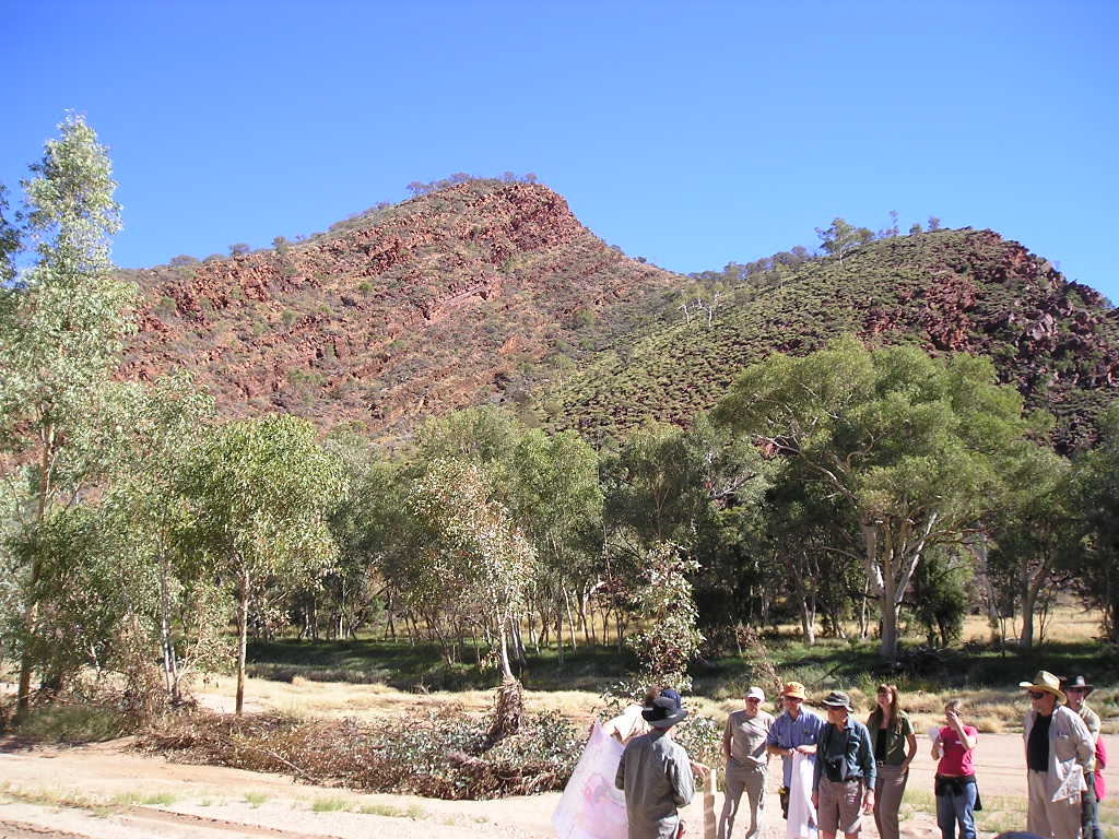
Stop 3B Ross River syncline

Stop 5 Strangways Metamorphic Complex, with lovely garnets (800C, 6Kbars)

Stop 6: fold in mylonite zone

Stop 7: Argument Gorge, mylonite zone

Stop 7: stretching lineations on mylonite surface (this was the first time I'd seen a good exposure of a mylonite, and suddenly everything I'd been reading about them made so much more sense!

Stop 9: garnet rich boudin (some exceed 1.5 cm)--I liked this stop!

Stop 9, garnet showing sense of shear

Stop 9: mafic layer + garnet sand

Stop 10: near Lizzy creek, view north to the Hearts Range

Stop 11: an old mica mine in a pegmatite dike. Note huge sheets of mica that still litter the ground


Stop 12 Bruna Granitic Gneiss--view to the east

Stop 13: Mt. Ruby garnet zone in amphibolite from the Hearts Range Metaigneous complex


Stop 14: Indiana Granite Hill. We climbed this one.
Us, at the top of Indiana Granite Hill (stop 14)

Stop 16: Huckitta Creek, Intense strain zone
Stop 16: folding
Stop 16: more of the intense strain


Stop 17: Large fold
Stop 17: large deformed pegmatite dike to the right of the above fold. Note boudins in the layers of the fold limb


Stop 19: fold in gneiss
Stop 19: view to the east


Stop 20: Bruna granitic gneiss:
Stop 20 garnet-rich metapelite:


Stop 20: a mylonite zone in gneiss. Note that the mylonite contains garnet, the gneiss does not.
Stop 21: a mica and garnet rich layer in gneiss:
Stop 21: folding in gneiss:

There was also a mid-conference filed trip--a one day trip to the west of Alice Springs, driving on sealed roads the entire time (in large tourist-style air conditioned busses). The person who sat next to me happened to have been from Tasmania, and graduated years ago from UTAS before moving to the mainland to do geology there. Needless to say we had some very pleasant discussions about the uni we both attended.
The rocks on the mid-confluence trip weren't as pretty (they hadn't been sufficiently deformed to show the pretty folding or nice minerals that we saw on the five day trip), but they were still nice, and we actually saw a few waterholes (one 30 feet deep) which stay wet year-round, despite the fact that the rest of the river course is dry.
Mid conference trip stop 1: looking west at the Arumba Sandstone
Mid-conference trip, stop 2 Elery water hole (and folding of the rocks)

Mid-conference trip Stop 3: anticline in Heavitree quartzite
Mid-conference trip Stop 3 Heavitree quartzite repeated above thrust fault
Mid Conference trip stop 3: Ormiston Gorge (with some nice folding showing)
Mid Conference trip stop 4: Mt. Saunders
Mid conference trip, stop 5: The waterhole at Glen Hellen Gorge

Note: all above photo captions were taken straight from the file names of the photo, I didn't have to look for my field notes from the trip today--I had the sense to give the photos meaningful names, including stop numbers and sometimes even P/T data promptly after taking them.

Saturday, 5 June 2010

Anorthosite and asphalt

I spent two days this week on a field trip in western Norway, where our guide assures us that the world’s best (ultra) high pressure rocks are located. It is my plan to do a proper field trip post, including photos, but in the mean time I’ll share with you a snippet of information I learned about one of the rock types we drove past, but did not stop at.

Near the town of Florø, Norway, there are a variety of white road cuts which are made of anorthosite. The primary (only?) mineral in anorthosite is plagioclase feldspar. In this area anorthosite is often quarried and used for making asphalt. Why? Several reasons:

* White colour of anorthosite makes whiter asphalt = better visibility for driving at night or under cloudy conditions.

* Plagioclase hardness (~6 on Mohs scale) makes for more durable, and therefore longer lasting asphalt.

* The plagioclase cleavage planes means that as cars drive on it and break it down the crystals maintain their edges, which provides better traction, even when wet.

Alas, I didn’t manage to get a photo of any of the anorthosite outcrops we passed—my camera has too long of a delay between pushing the button and taking a photo, which means that by the time I saw the outcrop it was too late to photograph it at the speeds our bus was traveling. But I was able to find a photo on line of an outcrop down near Bergen, which appears on this web page.

Tuesday, 15 September 2009

Pre-Conference Field Trip, Stop Two: Siccar Point

It has been nearly two weeks since I attended the Pre-Conference Field Trip, yet the memory of the day remains strong. I have already written about Stop One; today’s post continues our adventures as we follow in the footsteps of James Hutton, visiting the unmistakable unconformity at Siccar Point.

This outcrop is said to be one of the most significant in the history of the study of geology. Before Hutton published his theory on geologic time many people accepted Bishop Ussher’s calculations that the earth was only 6,000 years old. However, Hutton’s observations of geologic phenomena led him to realize that it must be far, far older than that to account for the sedimentary record. He observed erosion taking place in the world around him; saw how much sand a river can carry to an ocean over time, and reasoned that this process must have been going on for as long as there have been rivers. The rate at which the sand is deposited onto beaches or into lakes, or along a riverbed is measurable, and so estimates of the time needed to deposit a given thickness of sand may be calculated. He also noted that when sand is deposited by water, it always happens in horizontal layers. Comparing such layers of fresh sand, mud, and/or gravel with layers of sandstone, mudstone, and conglomerate leads one to the realization that the sedimentary rocks must have, at one time, been made up of loose sediment, before they became compacted and/or cemented into solid stone, and any sedimentary rocks which are folded or tilted must have been tilted or folded at some point after deposition and after becoming rock (or the sand would have slid back down into flat layers again).

The rocks in southern Scotland include two very different packages. The older of these packages is made up of Silurian sediments—poorly sorted sandstones (greywackes) which have been folded intensely enough that the bedding now stands on end in many locations rather than horizontally. The younger package is the “Old Red Sandstone, which was deposited during the Devonian. Hutton knew from his explorations in the region around Edinburgh that the red sandstones are reasonably flat-lying and outcrop to the north of the steeply tilted Silurian greywackes. He knew that there must be some place where the two rock types are in contact with one another, so he and some friends set out in a boat along the coast in search of it.

One can imagine the delight felt by his party when they discovered that contact, at Siccar Point. While it had been possible that there was a gentle transition from the steeply dipping sedimentary rock to the south into the flatter lying sandstones to the north, what they discovered was no gentle transition.

Instead they discovered evidence that the older rocks must have been deposited as typical flat-lying sands and muds of great thickness, transformed into rocks and folded so tightly that the layers now stand on end, the edges of the folds and some unknown amount of rock eroded away, and then, some time thereafter, the sands which were to become the “Old Red Sandstone” deposited atop them, before themselves becoming rock and then being subjected to erosion. Hutton argued that if sedimentary rates in the past operated on the same sort of time scales as they do today there is no way that all of that could possibly happen in so short a time as only 6,000 years. One of his companion on that trip, John Playfair, is recorded as having said that “The mind seemed to grow giddy by looking so far into the abyss of time” when they contemplated just how much time the entire process would have taken.

Indeed, what they couldn’t know as they stood upon this rocky shore contemplating "deep time" was just how much time is represented by just the period of erosion between the two rock units, which has subsequently been calculated at fully 55 million years, during which an ocean basin closed and a mountain range grew.

Unlike Hutton's first boat-trip to this location, our field trip approached the point by bus, traveling south from Edinburgh, and finally stopping in a field near the coast some 55 km to the east of Edinburgh. Travellers are greeted at the stop with a first information sign at the trail head,


and a second when one reaches the point at which one descends to the seaside.

The way was steep, but, fortunately, it wasn’t a rainy day, so the grass was dry, and we made our decent safely.


We then spent a pleasant time examining the rocks, and taking photographs before climbing back up the hill to return to civilization, content in our own observations that yes, indeed, this outcrop does record simply amazing amounts of time.

Sunday, 30 August 2009

Pre-conference field trip, stop one: Hollyrood Park, Edinburgh

I’ve been spending a week in Scotland for the MAPT conference. Some people manage to do live blogging of such things. I didn't. (To be fair, they told us in advance that there wouldn’t be a wireless connection available at the conference, so to cut down on the weight I'd be carrying to and from I didn’t bring my computer with me during the days, and have been too busy in the evenings visiting with an old friend with whom I am staying. So I’ll try to post highlights from the conference over the next few posts.

The conference started with a local field trip. We went first to Hollyrood Park, which is in the middle of the city. The most prominent feature of this park is Arthur’s Seat, which is the core of an extinct volcano, which erupted about 350 million years ago. Ten distinct lava flows (olivine +/- other minerals basalt) are distinguished in this area. Apparently there has not yet been a systematic flow-by-flow detailed comparison of the various compositions, if any students out there are interested in the subtle changes that a volcano undergoes during its eruptive cycle.

The second most prominent feature of the park is the sill which makes up Sailsbury crags. James Hutton, (a local man who is known as the father of geology) found an important contact here which helped to settle the debate between the “Neptunists” and the “Plutonists”. The former believed that crystalline rocks formed by precipitating out of sea water, while the latter believed that they had cooled from a molten source.

This outcrop showed that the crystalline rock had intruded into sedimentary layers and in the process, lifted up a layer of sandstone and oozed a short distance underneath that layer. This would not have been possible had it precipitated out of a liquid. Additional proof was provided by his friend, Sir James Hall, the father of experimental geology. Hall owned a foundry, so had access to the appropriate equipment to try melting rock. His experiments proved that one could melt basalt, cool it, and obtain a rock which looked much the same as the starting product. Therefore, the original must also have cooled from a molten source.

Another noteworthy feature of the park is the world’s first example of geological conservation. Hutton observed this hydrothermal vein cutting through the sill, altering the minerals and depositing hematite (iron ore). At the time this area was being actively quarried, and he requested that the quarrymen leave this particular part of the outcrop intact for future generations to observe the phenomena, and they did. The cliff wall is now quite a way behind the preserved portion of the outcrop.

Views from the park include Edinburgh’s castle, which sits upon another volcanic plug.

Stay tuned for my next post, when the field trip moves about 40 miles south to Siccard Point, the site of Hutton’s most famous unconformity.

Friday, 31 July 2009

An Alpine Field Trip

Last Friday, just before leaving work for the day, one of my colleagues mentioned to me that two of them would be heading on a field trip on Monday, and would I like to join them? For that sort of question there is only one answer possible.

He then provided me with this much advance information: I was to meet the other colleague at the train station on Monday to catch the 08:00 train to Como, where we will meet the first colleague, get in a car, and head to the field.

Once I arrived at the train station the purpose of the day’s journey was revealed; my colleagues were introducing a new graduate student to his field area. We first drove for about an hour along the western shore of the lake to Gravedona, where we stopped at a sore to pick up some stuff for lunch, and then went up hill from there, first to Dossa del Liro, then on to Caiaso. At our first stop we walked a short way up the gully and spent a pleasant hour looking at the various metamorphic rocks which have been dropped there by the stream in its rush to the lake. The intent was to familiarize the student with the many lithologies which are present in his field area, and more specifically to introduce us to the peridotite (photo to the right--the large garnet is ~2 cm long) so that if we were fortunate enough to find it "in place" later, we'd recognize it. We had along a copy of a 1968 paper which documents the presence of peridotite from the valley in which we'd be hiking, but none of my colleagues were quite certain where in the valley we'd find it.

The hike itself was wonderful--it was a lovely day. Sure, it was hot, but it has been hot every day since I arrive in Europe, so I'm started to adjust, and it was not quite as hot at that elevation (the sign at the trail head said 1000 meters) as it has been in down in the city. Driving up the hill to the trail head I kept seeing lovely old stone houses, and was delighted that there was one at the trail head, and quite a number of them along the trail. Some of the cottages have obviously been abandoned and are in poor repair, but one of the houses has a solar panel on the roof, which I consider to be a good indication that it is still in use today.

Walking up the valley we stopped now and then to admire various rock outcrops, such as this garnet migmatite (left), which is a metamorphic rock which went far enough down a subduction zone that the pressure/heat caused partial melting, or the intricate folds in this one (right).


Late in the afternoon we’d hiked far enough up the valley to reach a good-sized patch of snow that has survived the summer heat. I suppose one could call it a glacier, as the snow obviously stays year-round, yet it clearly doesn't have sufficent mass to cause the metamorphic crystallization of the ice in the lower levels, nor to flow down hill.


Just down hill from the snow-patch, I discovered some truly yummy wild strawberries, a true highlight of the day. I must confess that I ate most of them before remembering that I've a camera in my pocket, and it might be nice to record them for posterity. Fortunately, there was one remaining when I thought of it...


All in all it was a wonderful day, and I am so very glad I went. It was a joy to get out of the city, and to see some mountains! It was interesting listening to the various lectures on the rocks given the graduate student in the local language, as there are a number of geologic terms which are the same (or close enough to the same) in both languages, so I was able to understand more of those lectures than I did the random bits of other conversation that were scattered across the day. (Fortunately for me, both of my colleagues speak English and remembered to include me in conversations on a regular basis, but I do look forward to the language course they say I can take come September, I would like to be able to communicate a bit in the local language.)